

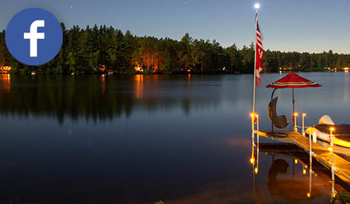
Welcome to New York State Campsite Photos (NYSCP)!
The most comprehensive photo guide to camping at State campgrounds across New York covering the Adirondack Park, the Thousand Islands, Central New York, Western New York and the Catskills / Taconic regions. This guide currently covers 97 campgrounds, 13,203 individual campsites and 161,884 campsite photos for you to peruse, along with many different tools to help you select the perfect campground and campsite that meets your needs.
Disclaimer: This site is managed and maintained by Dave McGrath for campers and is in no way affiliated with New York State, the Department of Environmental Conservation nor Aspire (ActiveNetwork, ReserveAmerica).
- Campgrounds
- Open Campgrounds (1)
- Schodack Island
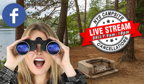
(opened Apr 19, 2024) - Recent Cancellations
- Post/Request Cancellation
- 9 Months Out Booking Buddy
Open Campgrounds
Open Campgrounds
- Schodack Island
(opened Apr 19, 2024)
- Allegany
(opened May 17, 2024) - Ausable Point
(opened May 17, 2024) - Bear Spring Mountain
(opened May 17, 2024) - Beaverkill
(opened May 17, 2024) - Bowman Lake
(opened May 17, 2024) - Brown Tract Pond
(opened May 17, 2024) - Buck Pond
(opened May 17, 2024) - Buttermilk Falls
(opened May 17, 2024) - Caroga Lake
(opened May 17, 2024) - Cayuga Lake
(opened May 17, 2024) - Cedar Point
(opened May 3, 2024) - Chenango Valley
(opened May 17, 2024) - Coles Creek
(opened May 17, 2024) - Cranberry Lake
(opened May 17, 2024) - Crown Point
(opened May 17, 2024) - Cumberland Bay
(opened May 17, 2024) - Darien Lakes
(opened May 17, 2024) - Delta Lake
(opened May 17, 2024) - Devils Tombstone
(opened May 17, 2024) - Eagle Point
(opened May 17, 2024) - Eighth Lake
(opened May 17, 2024) - Evangola
(opened May 17, 2024) - Fair Haven Beach
(opened May 17, 2024) - Fillmore Glen
(opened May 17, 2024) - Fish Creek
(opened May 10, 2024) - Forked Lake
(opened May 17, 2024) - Four Mile Creek
(opened May 17, 2024) - Frontier Town
(opened May 17, 2024) - Gilbert Lake
(opened May 17, 2024) - Glimmerglass
(opened May 17, 2024) - Golden Beach
(opened May 17, 2024) - Golden Hill
(opened May 17, 2024) - Grass Point
(opened May 17, 2024) - Green Lakes
(opened May 17, 2024) - Hamlin Beach
(opened May 17, 2024) - Hearthstone Point
(opened May 17, 2024) - Higley Flow
(opened May 17, 2024) - Jacques Cartier
(opened May 17, 2024) - Kenneth L Wilson
(opened May 17, 2024) - Keuka Lake
(opened May 17, 2024) - Kring Point
(opened May 3, 2024) - Lake Durant
(opened May 17, 2024) - Lake Eaton
(opened May 17, 2024) - Lake Erie
(opened May 17, 2024) - Lake George Battleground
(opened May 17, 2024) - Lake Harris
(opened May 17, 2024) - Lake Taghkanic
(opened May 17, 2024) - Lakeside
(opened May 17, 2024) - Letchworth
(opened May 17, 2024) - Lewey Lake
(opened May 17, 2024) - Limekiln Lake
(opened May 17, 2024) - Lincoln Pond
(opened May 17, 2024) - Little Pond
(opened May 17, 2024) - Long Point
(opened May 17, 2024) - Luzerne
(opened May 17, 2024) - Meacham Lake
(opened May 17, 2024) - Meadowbrook
(opened May 17, 2024) - Moffitt Beach
(opened May 17, 2024) - Mongaup Pond
(opened May 17, 2024) - Moreau Lake
(opened May 3, 2024) - Nicks Lake
(opened May 17, 2024) - North South Lake
(opened May 17, 2024) - Northampton Beach
(opened May 17, 2024) - Oquaga Creek
(opened May 17, 2024) - Paradox Lake
(opened May 17, 2024) - Piseco Lake
(opened May 17, 2024) - Putnam Pond
(opened May 17, 2024) - Robert H Treman
(opened May 17, 2024) - Robert Moses
(opened May 17, 2024) - Rogers Rock
(opened May 17, 2024) - Rollins Pond
(opened May 17, 2024) - Sacandaga
(opened May 17, 2024) - Sampson
(opened May 17, 2024) - Saranac Lake Islands
(opened May 17, 2024) - Scaroon Manor
(opened May 17, 2024) - Schodack Island
(opened Apr 19, 2024) - Selkirk Shores
(opened May 17, 2024) - Sharp Bridge
(opened May 17, 2024) - Southwick Beach
(opened May 10, 2024) - Stony Brook
(opened May 17, 2024) - Taconic Copake Falls
(opened May 10, 2024) - Taughannock Falls
(opened May 17, 2024) - Taylor Pond
(opened May 17, 2024) - Watkins Glen
(opened May 17, 2024) - Wellesley Island
(opened May 3, 2024) - Westcott Beach
(opened May 17, 2024) - Whetstone Gulf
(opened May 17, 2024) - Wilmington Notch
(opened May 10, 2024) - Woodland Valley
(opened May 17, 2024)
Open Before Memorial Day
Explore Campgrounds Tools
Find on a Map
Campsite Finder
Quick Peek
- Lakeside Camping - Adirondack Style
- Lakeside Camping - Big Lake Style
- Lakeside Camping - Boaters Delight
- Lakeside Camping - Adirondack Paddlers Dream
- Lakeside Camping - Beach Bums
- RVers Choice - Hookups
- RVers Choice - Big and Flat and Electric
- RVers Choice - RV Beach Bums
- Tenters - Tent Specific Sites
- Tenters - Hike-In Sites
- Tenters - Tent Spefic Watersite
- Getting Away - Private Sites
Campground Themes
CK
E
AK
TW
MB
AS
LK
MH
KG
MS
RW
GG
BJ
SC
WS
TF
JF
DB
MK
TC
AC
ES
SS
NH
NS
LA
AW
KL
AC
HJ
MW
DW
KE
JS
KB
AL
SP
S
DA
DH
JC
JF
MC
SC
DK
PA
ST
LR
MS
CD
LB
MA
MS
MC
BZ
BC
BB
ER
NB
DA
SH
SL
LM
LO
TZ
CY
JH
Powered by Parkware Campground Manager.
Select a Campground
-
Allegany
Western New York
-
Ausable Point
Adirondack Park
-
Bear Spring Mountain
Central New York
-
Beaverkill
Catskills / Taconic
-
Bowman Lake
Central New York
-
Brown Tract Pond
Adirondack Park
-
Buck Pond
Adirondack Park
-
Burnham Point
1000 Islands / Lake Ontario
-
Buttermilk Falls
Finger Lakes
-
Caroga Lake
Adirondack Park
-
Cayuga Lake
Finger Lakes
-
Cedar Point
1000 Islands / Lake Ontario
-
Chenango Valley
Central New York
-
Coles Creek
1000 Islands / Lake Ontario
-
Cranberry Lake
Adirondack Park
-
Crown Point
Adirondack Park
-
Cumberland Bay
Adirondack Park
-
Darien Lakes
Western New York
-
Delta Lake
Central New York
-
Devils Tombstone
Catskills / Taconic
-
Eagle Point
Adirondack Park
-
Eel Weir
Adirondack Park
-
Eighth Lake
Adirondack Park
-
Evangola
Western New York
-
Fair Haven Beach
1000 Islands / Lake Ontario
-
Fillmore Glen
Finger Lakes
-
Fish Creek
Adirondack Park
-
Forked Lake
Adirondack Park
-
Four Mile Creek
Western New York
-
Frontier Town
Adirondack Park
-
Gilbert Lake
Central New York
-
Glimmerglass
Central New York
-
Golden Beach
Adirondack Park
-
Golden Hill
Western New York
-
Grass Point
1000 Islands / Lake Ontario
-
Green Lakes
Central New York
-
Hamlin Beach
Western New York
-
Hearthstone Point
Adirondack Park
-
Higley Flow
Adirondack Park
-
Jacques Cartier
1000 Islands / Lake Ontario
-
Keewaydin
1000 Islands / Lake Ontario
-
Kenneth L Wilson
Catskills/ Taconic
-
Keuka Lake
Finger Lakes
-
Kring Point
1000 Islands / Lake Ontario
-
Lake Durant
Adirondack Park
-
Lake Eaton
Adirondack Park
-
Lake Erie
Western New York
-
Lake George Battleground
Adirondack Park
-
Lake Harris
Adirondack Park
-
Lake Taghkanic
Catskills / Taconic
-
Lakeside
Western New York
-
Letchworth
Western New York
-
Lewey Lake
Adirondack Park
-
Limekiln Lake
Adirondack Park
-
Lincoln Pond
Adirondack Park
-
Little Pond
Catskills / Taconic
-
Little Sand Point
Adirondack Park
-
Long Point
1000 Islands / Lake Ontario
-
Luzerne
Adirondack Park
-
Macomb Reservation
Adirondack Park
-
Max V Shaul
Catskills / Taconic
-
Meacham Lake
Adirondack Park
-
Meadowbrook
Adirondack Park
-
Moffitt Beach
Adirondack Park
-
Mongaup Pond
Catskills / Taconic
-
Moreau Lake
Adirondack Park
-
Nicks Lake
Adirondack Park
-
North South Lake
Catskills / Taconic
-
Northampton Beach
Adirondack Park
-
Oquaga Creek
Central New York
-
Paradox Lake
Adirondack Park
-
Piseco Lake
Adirondack Park
-
Point Comfort
Adirondack Park
-
Putnam Pond
Adirondack Park
-
Robert H Treman
Finger Lakes
-
Robert Moses
1000 Islands / Lake Ontario
-
Rogers Rock
Adirondack Park
-
Rollins Pond
Adirondack Park
-
Sacandaga
Adirondack Park
-
Sampson
Finger Lakes
-
Saranac Lake Islands
Adirondack Park
-
Scaroon Manor
Adirondack Park
-
Schodack Island
Catskills / Taconic
-
Selkirk Shores
1000 Islands / Lake Ontario
-
Sharp Bridge
Adirondack Park
-
Southwick Beach
1000 Islands / Lake Ontario
-
Stony Brook
Western New York
-
Taconic Copake Falls
Catskills / Taconic
-
Taconic Rudd Pond
Catskills / Taconic
-
Taughannock Falls
Finger Lakes
-
Taylor Pond
Adirondack Park
-
Thompsons Lake
Catskills / Taconic
-
Verona Beach
Central New York
-
Watkins Glen
Finger Lakes
-
Wellesley Island
1000 Islands / Lake Ontario
-
Westcott Beach
1000 Islands / Lake Ontario
-
Whetstone Gulf
Adirondack Park
-
Wilmington Notch
Adirondack Park
-
Woodland Valley
Catskills / Taconic
User Profile
User profiles coming very soon so you can personalize your experience on NYSCP using your Facebook Credentials:
Setup your equipment size.
Specify your favorite campgrounds.
Enter your dates of interest.
Enter public/private notes for individual campsites.
Enter reviews for campgrounds you have camped at.
Offer your cancellations and make cancellation requests.
And much more!